


 Copy
Copy WhatsApp
 Facebook
 Telegram
 X
X LinkedIn
 Email
Email Reddit
 Pinterest
 Line
Line VK
VK Blogger
 Tumblr
 OK
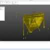
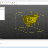
OKTrimble RealWorks 12 is a 3D point cloud processing software developed by Trimble Inc. It is designed for professionals working with 3D laser scanning and terrestrial LiDAR data, such as surveyors, engineers, architects, and construction professionals.
🧭 What is Trimble RealWorks 12?
Trimble RealWorks (TRW) is a powerful desktop application used to:
-
Import, register, and process 3D scan data (point clouds)
-
Analyze and model scanned environments
-
Extract deliverables such as meshes, surfaces, floor plans, 3D models, and inspection reports
It is primarily used in as-built documentation, industrial surveys, construction verification, and heritage documentation.
🧰 What is Trimble RealWorks 12 used for?
Key capabilities of TRW 12 include:
-
📍 Point Cloud Registration: Align multiple scans into a single coordinate system
-
🏗️ 3D Modeling: Create 3D models of buildings, structures, pipes, and terrain
-
🔍 Inspection & Comparison: Compare actual scanned data against design models or previous scans (deformation analysis, clash detection)
-
📐 Surface and Volume Calculations: Useful for construction monitoring and earthwork
-
🖼️ Visualization and Animation: Generate fly-through videos or visualizations for presentations
-
📤 Export to CAD/BIM: Send data to Revit, AutoCAD, or other platforms