
 Copy
Copy WhatsApp
 Facebook
 Telegram
 X
X LinkedIn
 Email
Email Reddit
 Pinterest
 Line
Line VK
VK Blogger
 Tumblr
 OK
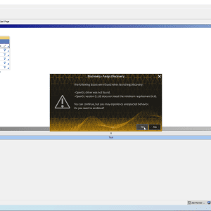
OKMicroSurvey FieldGenius 10.1 is an advanced version of the field data collection software developed by MicroSurvey Software, Inc. It is designed for surveying, construction staking, and geospatial data collection in the field. FieldGenius 10.1 is used to collect and manage survey data from total stations, GNSS receivers, and digital levels, and allows for seamless integration with CAD and GIS software for post-processing.
🎯 What the Program Is Used For:
MicroSurvey FieldGenius 10.1 is primarily used for:
-
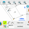
Surveying tasks, including topographic surveys, boundary surveys, and construction layout
-
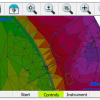
Field data collection and measurement recording from GNSS, total stations, and other surveying instruments
-
Stakeout and layout for construction projects and infrastructure
-
Real-time data processing and analysis
-
Field-to-office data transfer, enabling collaboration between field teams and office-based survey professionals
🛠️ Key Features of MicroSurvey FieldGenius 10.1:
✅ Surveying and Data Collection
-
Collect points, lines, and polylines in the field using total stations and GNSS receivers
-
Measure and record data for various types of surveys such as boundary, topographic, and construction staking
-
Support for multiple survey instruments, including Leica, Topcon, Sokkia, and Trimble