
 Copy
Copy WhatsApp
 Facebook
 Telegram
 X
X LinkedIn
 Email
Email Reddit
 Pinterest
 Line
Line VK
VK Blogger
 Tumblr
 OK
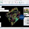
OKTerrasolid Suite v23 is a collection of professional software tools designed for processing, analyzing, and visualizing LiDAR point cloud data and aerial imagery, primarily used in geospatial, surveying, and mapping applications. It runs as a set of applications within Bentley MicroStation or OpenCities Map, providing high-performance tools for handling large-scale 3D spatial datasets.
🔍 What It Is Used For:
Terrasolid Suite v23 is used to:
-
Process and classify LiDAR point clouds from aerial, mobile, or terrestrial sources
-
Generate terrain models, contours, and 3D surface meshes
-
Extract features such as buildings, trees, power lines, and road networks
-
Perform orthophoto rectification, image mosaicking, and aerial triangulation
-
Conduct topographic mapping, asset inspection, and corridor modeling
-
Support urban planning, forestry analysis, and infrastructure design
🧰 Key Components of Terrasolid Suite v23:
✅ TerraScan
-
Core module for point cloud classification, editing, and surface modeling
✅ TerraMatch
-
For LiDAR data calibration, strip adjustment, and accuracy improvement
✅ TerraModeler
-
Builds DTMs (digital terrain models) and generates contours and cross-sections