
 Copy
Copy WhatsApp
 Facebook
 Telegram
 X
X LinkedIn
 Email
Email Reddit
 Pinterest
 Line
Line VK
VK Blogger
 Tumblr
 OK
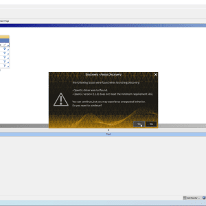
OKMicroSurvey STAR*NET 7.2 is a survey adjustment and data processing software developed by MicroSurvey Software, Inc. It is primarily used in the surveying and geospatial industries to perform precise adjustments and data analysis on field survey data collected using total stations, GNSS receivers, and leveling instruments. STAR*NET is widely used by surveyors, geodesists, and engineers for processing and adjusting field data, ensuring high accuracy in survey results, and producing reliable coordinate transformations and adjustment computations.
🎯 What the Program Is Used For:
MicroSurvey STAR*NET 7.2 is primarily used for:
-
Adjusting survey data collected from GNSS, total stations, and leveling instruments
-
Performing least squares adjustments for accurate network analysis and coordinate computation
-
Conducting geodetic transformations for accurate conversion of survey data into different coordinate systems
-
Ensuring the accuracy and quality control of survey results for various surveying projects
-
Creating reports and adjustment logs for quality assurance, project documentation, and regulatory compliance
🛠️ Key Features of MicroSurvey STAR*NET 7.2:
✅ Least Squares Adjustment
-
Perform least squares adjustments to ensure the most accurate results when combining measurements from multiple instruments and observations
-
Use network adjustment techniques to refine survey data and minimize errors in the final results
-
Apply weighting factors to prioritize measurements based on their reliability and precision